Season 2

Expedition works in 2018 were done basing on the license, dated 30.01.2018, given by the Director General of National Corporation for Antiquities & Museums (NCAM) – Dr. Abdelrahman Ali Mohamed to Prof. Mirosław Masojć, University of Wrocław, Poland as well as to Al Neelian University and NCAM.

During the second season of the expedition (2018) the further recognition of geology of the area as well as archaeological investigations were the main goals. On the following sites the work were in progress: EDAR 7, EDAR 133, EDAR 134, EDAR 135, EDAR 155.


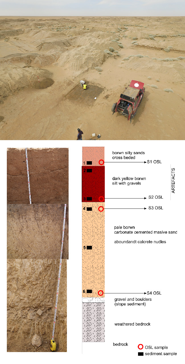
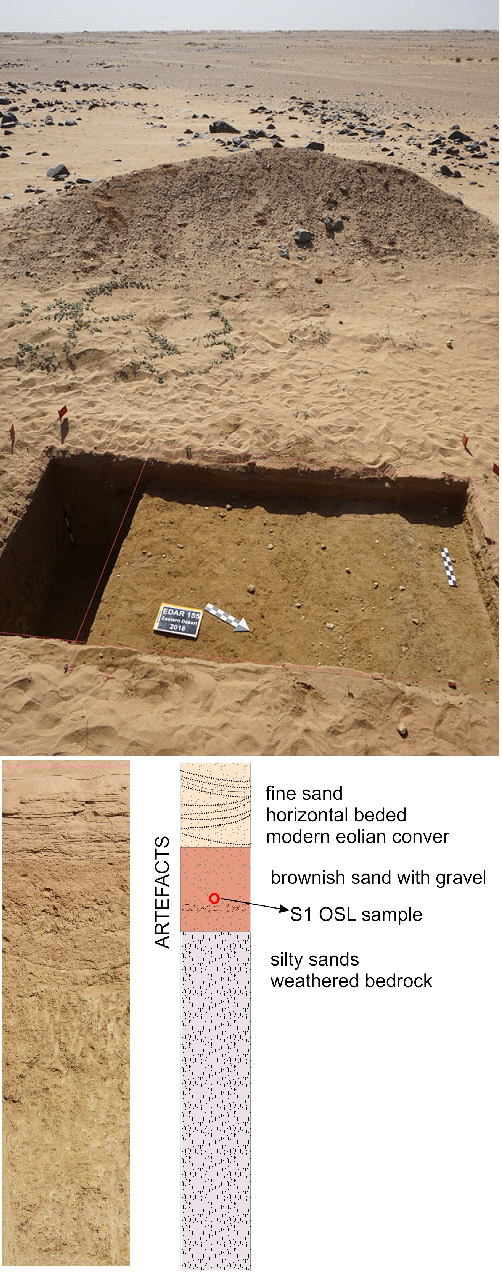
Not knowing any age information of EDAR archaeological sites, this season we proposed new dating method using cosmogenic nuclides, Beryllium-10 (Be-10) and Aluminum-26. Both nuclides are produced in rock and top of the atmosphere by nuclear interactions with the incoming secondary neutrons available and constituent elements of rock and atmosphere. The production rates of both Be-10 and Al-26 in quartz are well known as a function of latitude, altitude, and irradiation conditions. Finding these concentrations in 1g quartz sample gives information on either exposure time or burial time of the quartz sample. Stone artefacts along with grabbles in the cultural layer of this archaeological site have been experienced a time of surface exposure and then a time of burial. It is a challenging task for geochronologist to adapt in-situ cosmosgenic nuclides for archaeological dating application. In this Atbara location, especially Site 135 and Site 7 were investigated to adapt the in situ Be-10 & Al-26 burial dating method for estimation of ages relevant to the cultural layers revealed. Using atmospheric cosmogenic nuclides in soil profile samples can be used for both relative dating purpose with other proxies such as oxygen isotope and paleomagnetic intensity and paleoclimate study at the sampling site. The numbers of soil profile samples collected for two east walls of Site 135, one north wall of Site 135 and one west wall of Site 7 are 45, 38, 53, and 38, respectively. The number of mixed or single rock samples collected for these four sites are 2, 4, 3, and 3 respectively. We also collected two surface rock samples near Site 6 for references. Chemistry of these samples will be performed at KIGAM. Both AMS measurement and ICP-MS/AES are needed.

Site EDAR 7

Located in an old gold mine outcrop. Several Acheulean artifacts were found within the profiles, ca. 3 m deep. The profile (W) was sampled again by dr Kyeong Jo Kim for Be10 analyses (Fig. 1, 2).

Fig. 1. Description of the sampling localities for cosmogenic nuclide investigations at the EDAR archaeological sites
Fig. 2. Site EDAR 7, profile I (western). Works in progress. Sedimentological descriptions, OSL, AMS sampling. (picture from 2017 season)
Fig. 3. Site EDAR 133 under excavation
Fig. 4. EDAR 134, trench I/2017/2018. MSA site with in situ materials from the upper part of brown sandy silt layer
Fig. 6. Site EDAR 155 under excavation. MSA artefacts visible on the explored level. Below – stratigraphy of the site

Site EDAR 133

Heavily disturbed Acheulean site. Many hand axes found on earth piles (Fig. 3). The artifacts appeared within the gravel layer which probably can be correlated with the one below brown silts at the site 6 and 7 so it could have the same age as geological Unit II distinguish for the area.

Huge collection was obtained at the site. Many hand-axes with debitage. Most of the collection is not in the primary location.

Site EDAR 134

Heavily disturbed Acheulean and MSA site. Many hand axes as well as MSA artifacts found on earth piles (Fig. 4).

Despite this a preserved horizon with undisturbed, in situ MSA artifacts was found. Ca. 0,5 m brown sandy silt was removed by gold miners. Within the upper part of next layer – dark brown sand silt – MSA horizon was observed. The trench I/2017 was opened on 16 square meters. The excavation in 2018 continued on the same area. Several dozen of MSA Levallois artifact were found within a good stratigraphical location. This marks the age of sandy silts building the upper part of the sediments of the area. The site will be investigated further in the following season. Samples for AMS, OSL were taken.

Site EDAR 135

The most complete profile in the investigated area. Its depth reaches 5 meters (Fig. 5).

Profile on site EDAR 135 has been supplemented with Be10 and new OSL samples and Oxygen Isotope Ratio samples.

Fig. 5. Site EDAR 135 while sampling for OSL dating. The 5 meters-long profile is containing two archaeological horizons. At the depth of 3 m second horizon has been affiliated to Acheulean. This season the site was again sampled for Be 10 analyses. Another artifacts from the profile were discovered – attributed to Nubian MSA

Site EDAR 155

Newly discovered site located about 1,5 km SE from the main mine field.

MSA artifacts found in an area after gold miners. Small trench was opened for stratigraphic reasons – 8 square meters. Within the trench MSA artifacts were common in the top soil – sandy sands. Below the top horizon only a weathered rock was present on the site. No older horizons present. Presumably, judging by the geological position, this would be the younger face of MSA occupation of the area – younger than EDAR 134. The stratigraphy was documented and OSL samples were taken.

Conclusions

Archaeological sites are valuable in investigating past human occupation with respect to human evolution through the past environmental conditions. Especially, the eastern Sudan of Africa is very attractive with the possible passage of human movement from the south Africa between approximately 450,000 and 250,000 years ago. Although there were some evidences of early human occupation during this period in worldwide, it is very important to find clear evidences how the early human, homo erectus could have occupied in this region. The Atbara River currently reveals as an entirely flat landscape in a desert environment. A fortune comes for archaeologist to find the evidence of the past human presence in any place when any civilization activity brings a land modification which reveals a vertical soil profile by current human’s activity such as mining development. The Atbara River revealed by the gold mining activity is not completely helpful in finding the entire homo erectus presence for the known occupation period by the exposed soil profiles available in this region. The oldest OSL dating result up to now indicates that the ED Site 135’s layer which contains a number of stone artefacts is as old as ca. 250 ka. This just matches as the closest age of the end period of homo erectus in the eastern Sudan.

Next/final season of the project

Will be devoted to recognition of the deep located horizons with hand-axes and MSA artefacts recognized at site 135. Further surveying is planned as well as further excavation on chosen EDAR sites.

Team 2018